PROSLIDE will focus on the landslide-prone area of South Tyrol (Autonomous Province of Bozen/Bolzano). The area (~7400 km²) is characterized by a substantial internal heterogeneity in terms of topography, geology and climate. Exposed elements are fluctuating in space and time which raises the need for a reliable spatio-temporal landslide prediction. Extensive research has already been conducted to investigate deep-seated movements and debris flows in South Tyrol. Comparable few researchers tackled the topic of shallow landsliding by focusing primarily on the spatial domain. For South Tyrol, little is known about the interrelations of shallow landslide events and their spatio-temporal controls while associated prediction rules are not yet available.
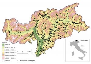 Figure: South Tyrol and inventoried slide-type movements. Note that the shown events mainly relate to damage causing landslides. Data source: (c) Open Geodatabase of the Autonomous Province of South Tyrol. Link: https://geoportal.buergernetz.bz.it/geodaten.asp
Passeier valley
For the physically-based approach, the decision was made to focus on a subcatchment located in the Passeier valley. This subcatchment covers an area of 53 km2, stretching from Meran in the South to Sankt Leonhard in the North. The valley has very steep slopes, with a median slope angle of 33 degrees. In terms of land use, 35% of the area is covered by forest, while the remaining area is used either as hay pastures or as meadows. With regards to the geology, most of the surfacing geology consists of quaternary lodgement tills and paragneiss, orthogneiss and micaschist lithologies from the Texel unit (see also the Figure below).
Analysis of the IFFI database indicated that a large event took place in the Passeier valley on August 5th, 2016. The IFFI database contains 16 landslides located in the Passeier valley that occurred on this day. A further analysis, consisting of manually mapping landslide signals on Planetscope and Ra
pidEye satellite imagery, resulted in 55 mapped landslides for the event. The locations of these landslides are also given in subfigure (d) below.
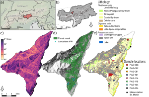
Figure: Overview of the Passeier valley, with its location within Europe (a) and South Tyrol (b). The slope map is given in (c) and the forest cover from the 2004 DSM is mapped in (d) with the landslides in the IFFI inventory registered to the August 5th, 2016 event. The surfacing lithologies are mapped in subfigure (e), source: detailed geological map from the Open Geodatabase (https://geoportal.buergernetz.bz.it/geodaten.asp). Subfigure (e) also shows the locations of the field visits and the location of the St. Martin meteorological station.