PROSLIDE: Integration of static and dynamic landslide controls at multiple-scales using data-driven and physically-based methods – exploring new opportunities for the PRediction Of shallow landSLIDEs
Landslides are widespread phenomena in mountain areas of the world and play a key role in landscape evolution. These potentially hazardous geomorphological processes pose a serious threat to human lives, settlements and infrastructure. The efficiency of measures that strive for a pro-active reduction of landslide impacts (e.g. land management, early warning), heavily depends on the knowledge of where and when future slope instability may occur. However, the prediction of landslides still constitutes a scientific challenge, mainly due to a complex interplay of their static and dynamic causes and triggers (e.g. topography, lithology, snow melt, heavy rainfalls) and associated spatio-temporal data required for modelling.
PROSLIDE focuses on (primary non-human caused) shallow slope instability in the province of South Tyrol (Italy). The main objective is to improve the predictability of shallow landslides by integrating innovative environmental data and novel modelling designs at multiple spatial and temporal scales. Main innovations of the project include (i) the exploitation of remote sensing techniques and data for the spatio-temporal characterization of landslide controls (e.g. meteorological RADAR; satellite derived snow and soil moisture; unmanned aerial vehicle based laser scanning), (ii) the development of novel modelling strategies that allow to integrate heterogeneous model inputs, data-driven approaches and physically-based models, (iii) the explicit elaboration of optimal investigation scales (e.g. dependency of the models on spatial and temporal data aggregation strategies).
The iterative methodical workflow comprises the gathering, processing and analysis of landslide-related ground truth information (incl. field campaigns) and newly generated remote sensing data (WP1 and WP2), the province-wide data-driven modelling of critical threshold conditions and spatio-temporal landslide likelihoods (WP3), dynamic physically-based modelling of slope stability at catchment scale (WP4) and the method integration and in-depth result evaluation (WP5). The results are expected to provide new insights into underlying geomorphic processes, landslide predictability in space and time and associated opportunities for the purpose of landslide forecasting in the context of the provincial Civil Protection Warning Center.
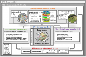
Figure: Iterative methodical workflow for PROSLIDE. The illustrations exemplarily highlight some available data sets (e.g. top left: landslide data; top center: EO and RADAR based landslide controls) and some potential spatial partitioning strategies (center; colors: large drainage basins; black borders: small drainage basins; red border: slope-units; shading effect: 10 m pixel-based representation).
The interdisciplinary PROSLIDE group consists of researchers and stakeholders with complementary expertise in Geomorphology, Geology, Soil science, Hydrology, Meteorology and Remote sensing. The institute for Earth Observation of Eurac and the Institute of Geography of the University of Innsbruck are supported by various local stakeholders:
- Office for Geology and Building Material Testing (contact person: Volkmar Mair)
- Civil Protection Agency (contact person: Roberto Dinale)
and renowned research institutions:
- IRPI CNR (Research Institute for Geo-Hydrological Protection of the Italian National Research Council) (contact persons: Stefano Luigi Gariano, Maria Teresa Brunetti, Massimo Melillo, Silvia Peruccacci)
- Austrian Academy of Sciences (ÖAW)
- University of Padova (contact person: Marco Borga)
The project is financed by the Autonomous Province of Bozen/Bolzano-South Tyrol (call: Research South Tyrol 2019). Duration: October , 2020 – End of 2022.
![]()
![]()